
Auerbach in der Oberpfalz
91275 Auerbach in der Oberpfalz, Deutschland
Stone City | Hiking & Climbing
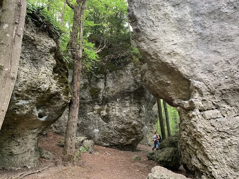
The Stone City near Auerbach is one of those places that you don't just visit, but experience through walking, looking, and marveling. Between Neuhaus and Auerbach rises a striking ensemble of dolomite rocks and rock towers in the Wellucker Forest, which truly deserves its name: With a bit of imagination, the shapes resemble the walls, towers, and alleys of a silent city made of stone. The location on the Karst Hiking Trail, the proximity to the Maximiliansgrotte, and its integration into the Franconian karst and climbing landscape make the area a destination for hikers, nature lovers, and climbers alike. Official tourism and geotope information describes the Stone City as an impressive rock formation and natural monument, which is accessible via a hiking parking lot and characterized by its distinctive rocks such as the Two Brothers, the Spitze Turm, and the Waldkopf. ([ostbayern-tourismus.de](https://www.ostbayern-tourismus.de/attraktionen/steinerne-stadt-78362b9999?utm_source=openai))
Hike to the Stone City and Karst Hiking Trail
If you want to experience the Stone City on foot, you will find one of the most exciting options in the region with the Karst Hiking Trail. The city of Auerbach explicitly refers to this route as a connection from Neuhaus to the Maximiliansgrotte, to the Stone City, and to the Vogelherdgrotte. Thus, the Stone City is not just a single viewpoint or rock block, but part of a whole hiking idea where caves, rock walls, and karst formations belong together. The VGN also describes the Karst Hiking Trail as a hiking path with references to rocks and caves, which vividly illustrates the theme of geology and connects the excursion into the landscape with informational value. Particularly appealing is that the path does not feel like a technical educational trail, but rather like a natural walk through a forest where the rocks suddenly appear and change the orientation of the landscape. For this reason, the Stone City is suitable for visitors who enjoy hiking with open eyes, taking photographs, and discovering small details along the way. The rocks appear densely grouped in some places, while in others they stand like free-standing towers, allowing new perspectives to emerge step by step. Those planning the tour should allow time for breaks, as the surroundings of the Maximiliansgrotte, the rock towers, and the forest paths invite you to linger. ([auerbach.de](https://www.auerbach.de/kultur-freizeit/wandern-radwege/))
Particularly helpful is the classification of the Stone City within the larger karst landscape of the Northern Franconian Alb. This is precisely where the appeal of the hiking destination lies: The hike is not only movement through the forest but also an encounter with the geological history of the region. The area is part of a Karst Hiking Trail, a path that makes rock formation, weathering, and cave development visible. Those interested in the landscape will find a connection between nature experience and knowledge transfer here, without the place losing its wild character. The Stone City is therefore not an isolated photo spot, but a landscape hub where hiking trails, rock formations, and sightlines overlap. This makes the visit attractive for different target groups: Casual hikers receive an impressive nature experience, while those interested in geology can examine the formations even more closely. For content planning and SEO, this topic is central because the search intention behind terms like hiking, Franconian Switzerland, Franconian Jura, and Karst Hiking Trail is very close to the actual use of the place. ([auerbach.de](https://www.auerbach.de/kultur-freizeit/wandern-radwege/))
Parking and Access to the Stone City near Auerbach
Access is one of the most important practical points for anyone wishing to visit the Stone City. Frankenjura.com describes the access very specifically: From Neuhaus, drive to Krottensee and from there continue towards the Maximiliansgrotte. Then continue on the forest road in the same direction, towards Sackdilling. After about 1000 meters, you reach an intersection in a dip; about 150 meters later, there is a designated hiking parking lot on the right. This is the best place to park if you want to head to the Stone City or the Two Brothers. The approach is short: From the parking lot, a wide path leads across the forest road after about 70 meters to the Two Brothers, which form the first towers of the Stone City from this direction. For visitors, this means that the most important rock formations are reachable after a short walk, making the place interesting for a spontaneous outing. At the same time, the description shows that the route is not an urban excursion destination with infrastructure in the classical sense, but a natural place where proper orientation and good footwear remain important. ([frankenjura.com](https://www.frankenjura.com/klettern/poi/16476))
For the search intention around parking, it is particularly important that visitors should not park in the middle of the rock area, but at a designated hiking parking lot. This reduces conflicts with forest and access roads and fits with the integration of the area into the natural space. Even though the place is very well developed, it remains ecologically sensitive. Therefore, it is sensible to consider the parking issue not only as a service topic but also as part of the visitor management concept. The short access time of two to four minutes to the Two Brothers makes the area attractive for hikers and climbers who do not want a long approach, while still seeking a genuine nature destination. For SEO, this topic is particularly strong because search terms like parking, access, and hiking parking lot express a clear practical intention. Therefore, the text should not only mention the parking lot but also the route to it and the fact that the parking lot is located on the forest road between Maximiliansgrotte and Sackdilling. This combination of route description, natural site, and short accessibility shapes user expectations at the Stone City. ([frankenjura.com](https://www.frankenjura.com/klettern/poi/16476))
Climbing at the Stone City: Two Brothers, Spitze Turm, and Waldkopf
The Stone City is not only a hiking destination but also a well-known climbing area. The official geotope entry of the Bavarian State Office for the Environment explicitly states that the area is used as a climbing garden. Frankenjura.com lists the accesses and routes to the individual rocks, showing that the Stone City is firmly anchored in the regional climbing scene. Particularly striking are the Two Brothers, two mushroom-shaped rocks at the entrance of the rock group. In addition, the Spitze Turm and the Waldkopf are among the most well-known formations. These names are not only poetic designations but also help with orientation in the terrain and in the climbing guides. For visitors interested in climbing or topos, the Stone City is thus a classic example of the fusion of natural monument and sport climbing area. The rocks are compact, easily recognizable, and located in a very scenic environment. At the same time, the route overview shows that the area remains exciting for both experienced climbers and sportily interested visitors, as history, geology, and movement meet directly here. ([umweltatlas.bayern.de](https://www.umweltatlas.bayern.de/standortauskunft/rest/reporting/sb_geotope/generate/Geotope.pdf?additionallayerfieldvalue=371R049&utm_source=openai))
In the broader regional context, the topic of climbing in Auerbach and the Franconian Jura plays a prominent role. The city of Auerbach describes its rocks and climbing routes as part of a world-renowned sport climbing region and points out that the tradition of red-point climbing was shaped here. For the Stone City, this regional embedding is important because it explains why the place appears in search queries related to climbing, bouldering, and topos. Even if individual search terms are very modern or sport-specific, the real core information remains the same: The Stone City is a rock area used as a climbing garden and is attractive due to its distinctive towers, good accessibility, and location in the Franconian Jura. Those who know the region quickly understand why such rock formations have significance not only ecologically but also sportingly. For content structure, this means that the climbing perspective should not appear as a side topic but as an essential part of the local identity. Especially at a location like this, hiking and climbing go together because both uses build on the same rocky landscape. ([auerbach.de](https://auerbach.de/kultur-freizeit/freizeit-sport/))
Geology, Dolomite Rocks, and Natural Monument in the Wellucker Forest
The geological aspect of the Stone City is at least as exciting as its use as a hiking and climbing destination. The Environmental Atlas Bavaria lists the geotope under the number 371R049 and describes it as an impressive ensemble of dolomite rocks that are heavily fissured and thus break into individual rock towers. The particularly striking Two Brothers rocks are mentioned, where the differing weathering behavior of individual horizons of the thick-bedded Franconian dolomite is displayed. The dataset states that the geotope has a size of about 250 by 150 meters, is located at around 480 meters in height, and is integrated into the Northern Franconian Alb. Additionally, the management plan of the FFH area Wellucker Wald north of Königstein describes the Stone City rocks as typical locations for certain habitats and refers to the free-standing rocks of the Stone City as characteristic sites within the area. This information makes it clear that the Stone City is not an interchangeable rock but a geologically and ecologically sensitive natural monument with clear characteristics. ([umweltatlas.bayern.de](https://www.umweltatlas.bayern.de/standortauskunft/rest/reporting/sb_geotope/generate/Geotope.pdf?additionallayerfieldvalue=371R049&utm_source=openai))
The visual effect of the rocks arises from the combination of shape, structure, and surroundings. The geotope text mentions hollows at the mushroom stems, which is the typical shape where the rocks appear narrower at the bottom and thus resemble mushrooms. This gives the Two Brothers their special character. The rocks are also situated in a forest environment that still conveys a natural impression in many places and does not overly expose the formations. As a result, the Stone City appears more like a hidden rock labyrinth than an open rock arena. The appeal arises not only from the height of individual towers but from the interplay of many rock blocks, gaps, and forest edges. Those taking photos should pay close attention to these perspectives, as the rocks appear completely different from various angles. For the description on a website, this is important because it explains why the Stone City cannot be captured in one sentence as a single rock. It is an ensemble, a small landscape, and thus a typical case for content-rich SEO texts with references to nature, hiking, and climbing. ([umweltatlas.bayern.de](https://www.umweltatlas.bayern.de/standortauskunft/rest/reporting/sb_geotope/generate/Geotope.pdf?additionallayerfieldvalue=371R049&utm_source=openai))
The Stone City in the Auerbach Hiking and Leisure Network
The Stone City unfolds its full effect when viewed not in isolation, but as part of the Auerbach hiking and leisure area. The city of Auerbach points to numerous marked hiking and cycling paths and explicitly mentions the Karst Hiking Trail as a connection from Neuhaus to the Maximiliansgrotte, to the Stone City, and to the Vogelherdgrotte. At the same time, it describes climbing in the region as a fixed part of the local leisure culture. This combination is particularly attractive for visitors: Those traveling to the Stone City find not just a single attraction but a starting point for further nature experiences in the vicinity of Neuhaus, Krottensee, Maximiliansgrotte, and the Krottenseer Forest. This makes the place a building block in a whole landscape of experiences where caves, rocks, forest paths, and sporting activities belong together. For the search terms Franconian Switzerland and Franconian Jura, this classification is particularly fitting, as the Stone City lies precisely at the intersection of geology, nature tourism, and active leisure use. ([auerbach.de](https://www.auerbach.de/kultur-freizeit/wandern-radwege/))
The official tourism description also supports this classification: It refers to the Stone City as an impressive rock formation between Neuhaus and Auerbach and emphasizes that the rocks, with a bit of imagination, appear like buildings of a stone city. This image is strong enough to be repeatedly referenced in titles, meta-data, and social texts because it makes the place immediately understandable. At the same time, it is factually correct, as the rock group stands out precisely because of its multitude of towers and formations. Those writing content for a website, a leisure guide, or a local landing page should therefore not only gather the facts but arrange them in a clear user logic: first the nature image, then the hike, then the access, followed by climbing and geology. This creates a text that truly addresses search intentions and does not just list keywords. The Stone City is excellent for this because it is not exhausted in one sentence but has multiple layers: landscape, movement, orientation, sport, and natural monument. This very multi-layered nature makes the place strong in SEO and content-wise interesting. ([ostbayern-tourismus.de](https://www.ostbayern-tourismus.de/attraktionen/steinerne-stadt-78362b9999))
Sources:
Mehr anzeigenWeniger anzeigen
Stone City | Hiking & Climbing
The Stone City near Auerbach is one of those places that you don't just visit, but experience through walking, looking, and marveling. Between Neuhaus and Auerbach rises a striking ensemble of dolomite rocks and rock towers in the Wellucker Forest, which truly deserves its name: With a bit of imagination, the shapes resemble the walls, towers, and alleys of a silent city made of stone. The location on the Karst Hiking Trail, the proximity to the Maximiliansgrotte, and its integration into the Franconian karst and climbing landscape make the area a destination for hikers, nature lovers, and climbers alike. Official tourism and geotope information describes the Stone City as an impressive rock formation and natural monument, which is accessible via a hiking parking lot and characterized by its distinctive rocks such as the Two Brothers, the Spitze Turm, and the Waldkopf. ([ostbayern-tourismus.de](https://www.ostbayern-tourismus.de/attraktionen/steinerne-stadt-78362b9999?utm_source=openai))
Hike to the Stone City and Karst Hiking Trail
If you want to experience the Stone City on foot, you will find one of the most exciting options in the region with the Karst Hiking Trail. The city of Auerbach explicitly refers to this route as a connection from Neuhaus to the Maximiliansgrotte, to the Stone City, and to the Vogelherdgrotte. Thus, the Stone City is not just a single viewpoint or rock block, but part of a whole hiking idea where caves, rock walls, and karst formations belong together. The VGN also describes the Karst Hiking Trail as a hiking path with references to rocks and caves, which vividly illustrates the theme of geology and connects the excursion into the landscape with informational value. Particularly appealing is that the path does not feel like a technical educational trail, but rather like a natural walk through a forest where the rocks suddenly appear and change the orientation of the landscape. For this reason, the Stone City is suitable for visitors who enjoy hiking with open eyes, taking photographs, and discovering small details along the way. The rocks appear densely grouped in some places, while in others they stand like free-standing towers, allowing new perspectives to emerge step by step. Those planning the tour should allow time for breaks, as the surroundings of the Maximiliansgrotte, the rock towers, and the forest paths invite you to linger. ([auerbach.de](https://www.auerbach.de/kultur-freizeit/wandern-radwege/))
Particularly helpful is the classification of the Stone City within the larger karst landscape of the Northern Franconian Alb. This is precisely where the appeal of the hiking destination lies: The hike is not only movement through the forest but also an encounter with the geological history of the region. The area is part of a Karst Hiking Trail, a path that makes rock formation, weathering, and cave development visible. Those interested in the landscape will find a connection between nature experience and knowledge transfer here, without the place losing its wild character. The Stone City is therefore not an isolated photo spot, but a landscape hub where hiking trails, rock formations, and sightlines overlap. This makes the visit attractive for different target groups: Casual hikers receive an impressive nature experience, while those interested in geology can examine the formations even more closely. For content planning and SEO, this topic is central because the search intention behind terms like hiking, Franconian Switzerland, Franconian Jura, and Karst Hiking Trail is very close to the actual use of the place. ([auerbach.de](https://www.auerbach.de/kultur-freizeit/wandern-radwege/))
Parking and Access to the Stone City near Auerbach
Access is one of the most important practical points for anyone wishing to visit the Stone City. Frankenjura.com describes the access very specifically: From Neuhaus, drive to Krottensee and from there continue towards the Maximiliansgrotte. Then continue on the forest road in the same direction, towards Sackdilling. After about 1000 meters, you reach an intersection in a dip; about 150 meters later, there is a designated hiking parking lot on the right. This is the best place to park if you want to head to the Stone City or the Two Brothers. The approach is short: From the parking lot, a wide path leads across the forest road after about 70 meters to the Two Brothers, which form the first towers of the Stone City from this direction. For visitors, this means that the most important rock formations are reachable after a short walk, making the place interesting for a spontaneous outing. At the same time, the description shows that the route is not an urban excursion destination with infrastructure in the classical sense, but a natural place where proper orientation and good footwear remain important. ([frankenjura.com](https://www.frankenjura.com/klettern/poi/16476))
For the search intention around parking, it is particularly important that visitors should not park in the middle of the rock area, but at a designated hiking parking lot. This reduces conflicts with forest and access roads and fits with the integration of the area into the natural space. Even though the place is very well developed, it remains ecologically sensitive. Therefore, it is sensible to consider the parking issue not only as a service topic but also as part of the visitor management concept. The short access time of two to four minutes to the Two Brothers makes the area attractive for hikers and climbers who do not want a long approach, while still seeking a genuine nature destination. For SEO, this topic is particularly strong because search terms like parking, access, and hiking parking lot express a clear practical intention. Therefore, the text should not only mention the parking lot but also the route to it and the fact that the parking lot is located on the forest road between Maximiliansgrotte and Sackdilling. This combination of route description, natural site, and short accessibility shapes user expectations at the Stone City. ([frankenjura.com](https://www.frankenjura.com/klettern/poi/16476))
Climbing at the Stone City: Two Brothers, Spitze Turm, and Waldkopf
The Stone City is not only a hiking destination but also a well-known climbing area. The official geotope entry of the Bavarian State Office for the Environment explicitly states that the area is used as a climbing garden. Frankenjura.com lists the accesses and routes to the individual rocks, showing that the Stone City is firmly anchored in the regional climbing scene. Particularly striking are the Two Brothers, two mushroom-shaped rocks at the entrance of the rock group. In addition, the Spitze Turm and the Waldkopf are among the most well-known formations. These names are not only poetic designations but also help with orientation in the terrain and in the climbing guides. For visitors interested in climbing or topos, the Stone City is thus a classic example of the fusion of natural monument and sport climbing area. The rocks are compact, easily recognizable, and located in a very scenic environment. At the same time, the route overview shows that the area remains exciting for both experienced climbers and sportily interested visitors, as history, geology, and movement meet directly here. ([umweltatlas.bayern.de](https://www.umweltatlas.bayern.de/standortauskunft/rest/reporting/sb_geotope/generate/Geotope.pdf?additionallayerfieldvalue=371R049&utm_source=openai))
In the broader regional context, the topic of climbing in Auerbach and the Franconian Jura plays a prominent role. The city of Auerbach describes its rocks and climbing routes as part of a world-renowned sport climbing region and points out that the tradition of red-point climbing was shaped here. For the Stone City, this regional embedding is important because it explains why the place appears in search queries related to climbing, bouldering, and topos. Even if individual search terms are very modern or sport-specific, the real core information remains the same: The Stone City is a rock area used as a climbing garden and is attractive due to its distinctive towers, good accessibility, and location in the Franconian Jura. Those who know the region quickly understand why such rock formations have significance not only ecologically but also sportingly. For content structure, this means that the climbing perspective should not appear as a side topic but as an essential part of the local identity. Especially at a location like this, hiking and climbing go together because both uses build on the same rocky landscape. ([auerbach.de](https://auerbach.de/kultur-freizeit/freizeit-sport/))
Geology, Dolomite Rocks, and Natural Monument in the Wellucker Forest
The geological aspect of the Stone City is at least as exciting as its use as a hiking and climbing destination. The Environmental Atlas Bavaria lists the geotope under the number 371R049 and describes it as an impressive ensemble of dolomite rocks that are heavily fissured and thus break into individual rock towers. The particularly striking Two Brothers rocks are mentioned, where the differing weathering behavior of individual horizons of the thick-bedded Franconian dolomite is displayed. The dataset states that the geotope has a size of about 250 by 150 meters, is located at around 480 meters in height, and is integrated into the Northern Franconian Alb. Additionally, the management plan of the FFH area Wellucker Wald north of Königstein describes the Stone City rocks as typical locations for certain habitats and refers to the free-standing rocks of the Stone City as characteristic sites within the area. This information makes it clear that the Stone City is not an interchangeable rock but a geologically and ecologically sensitive natural monument with clear characteristics. ([umweltatlas.bayern.de](https://www.umweltatlas.bayern.de/standortauskunft/rest/reporting/sb_geotope/generate/Geotope.pdf?additionallayerfieldvalue=371R049&utm_source=openai))
The visual effect of the rocks arises from the combination of shape, structure, and surroundings. The geotope text mentions hollows at the mushroom stems, which is the typical shape where the rocks appear narrower at the bottom and thus resemble mushrooms. This gives the Two Brothers their special character. The rocks are also situated in a forest environment that still conveys a natural impression in many places and does not overly expose the formations. As a result, the Stone City appears more like a hidden rock labyrinth than an open rock arena. The appeal arises not only from the height of individual towers but from the interplay of many rock blocks, gaps, and forest edges. Those taking photos should pay close attention to these perspectives, as the rocks appear completely different from various angles. For the description on a website, this is important because it explains why the Stone City cannot be captured in one sentence as a single rock. It is an ensemble, a small landscape, and thus a typical case for content-rich SEO texts with references to nature, hiking, and climbing. ([umweltatlas.bayern.de](https://www.umweltatlas.bayern.de/standortauskunft/rest/reporting/sb_geotope/generate/Geotope.pdf?additionallayerfieldvalue=371R049&utm_source=openai))
The Stone City in the Auerbach Hiking and Leisure Network
The Stone City unfolds its full effect when viewed not in isolation, but as part of the Auerbach hiking and leisure area. The city of Auerbach points to numerous marked hiking and cycling paths and explicitly mentions the Karst Hiking Trail as a connection from Neuhaus to the Maximiliansgrotte, to the Stone City, and to the Vogelherdgrotte. At the same time, it describes climbing in the region as a fixed part of the local leisure culture. This combination is particularly attractive for visitors: Those traveling to the Stone City find not just a single attraction but a starting point for further nature experiences in the vicinity of Neuhaus, Krottensee, Maximiliansgrotte, and the Krottenseer Forest. This makes the place a building block in a whole landscape of experiences where caves, rocks, forest paths, and sporting activities belong together. For the search terms Franconian Switzerland and Franconian Jura, this classification is particularly fitting, as the Stone City lies precisely at the intersection of geology, nature tourism, and active leisure use. ([auerbach.de](https://www.auerbach.de/kultur-freizeit/wandern-radwege/))
The official tourism description also supports this classification: It refers to the Stone City as an impressive rock formation between Neuhaus and Auerbach and emphasizes that the rocks, with a bit of imagination, appear like buildings of a stone city. This image is strong enough to be repeatedly referenced in titles, meta-data, and social texts because it makes the place immediately understandable. At the same time, it is factually correct, as the rock group stands out precisely because of its multitude of towers and formations. Those writing content for a website, a leisure guide, or a local landing page should therefore not only gather the facts but arrange them in a clear user logic: first the nature image, then the hike, then the access, followed by climbing and geology. This creates a text that truly addresses search intentions and does not just list keywords. The Stone City is excellent for this because it is not exhausted in one sentence but has multiple layers: landscape, movement, orientation, sport, and natural monument. This very multi-layered nature makes the place strong in SEO and content-wise interesting. ([ostbayern-tourismus.de](https://www.ostbayern-tourismus.de/attraktionen/steinerne-stadt-78362b9999))
Sources:
Upcoming Events
No events found
Frequently Asked Questions
Reviews
Nils Paellmann
20. October 2023
Fantastic stone formations and a great place for hiking. The hiking paths are clearly laid out. We spent roughly two hours on a 4.7 km (2.9 miles) hike this morning.
Brian Parker
13. September 2021
Enchanting close easy hike with beautiful karst topography. Just sampled today but will return for a more serious investigation.
Elizabeth Hughes-Hageman
1. January 2023
Great place to drive to, park, and hike. Good way point and map system throughout the trails. Some inclines but was easily hike by my four kids aged 13-3.
Olaf van der Hee
20. March 2022
Area with many huge stone formations. You can walk around and through them.
Ralf Steinstraesser
9. March 2023
Really nice hiking tour through the 'stony city'.